
Easter Island is one of the most remote inhabited islands in the world. The nearest inhabited land lies in central Chile, 3,500 kilometers away (except some tiny islands closer with only several hundred people living on it). The beginning of the colonialisation by Polynesians is still controversial, and the estimates range between 4th and 13th century AC, with the 11th century being the most likely.
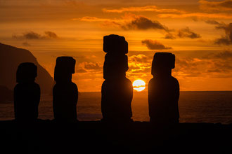
To worship their ancestors, the locals built the world-famous Moai´s, statues carved from volcanic tuff of the Rano Raraku volcano. Almost 1000 statues were built, the tallest 11m high and 90 tons heavy. While the there is no doubt about the purpose and the carving of the statues, it´s still an unsolved mystery how they transported this massive stone work from Rano Raraku to the varous religious sites, mainly at the costal area.
The “Moai” culture did end around the 15th century with internal clan feuds raging in the country. All Moai´s were toppled (think of the Saddam Hussein statue in Bagdad that was toppled as one of the first actions after Bagdad was taken/freed by the U.S.) and only re-erected for tourism/conservation starting in the 1960s.
The name "Easter Island" was given by the island's first recorded European visitor, the Dutch explorer Jacob Roggeveen, who encountered it on Easter Sunday 1722.
Currently, over 70´000 tourists visit the Easter Islands annually, which means over 11 tourists per inhabitant (slightly less than 6000 people live on the island).
Almost all goods are imported, and the entire business of the island relates to tourism. The island is too small (only 116 square kilometers) and rocky for large scale agriculture, and the water is too low-nutrient for successful fishing activities.
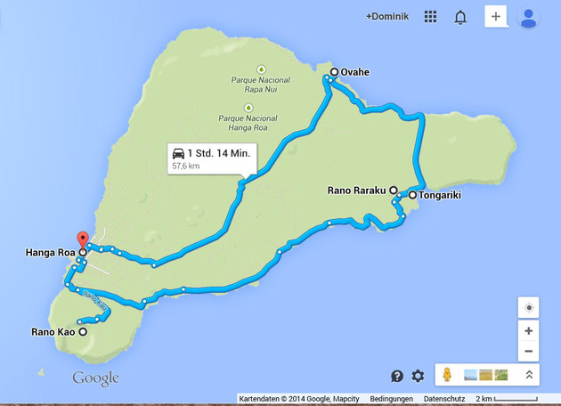
Visiting the Moai´s on organized tours, - or what I preferred – by rental car is the obvious main tourist activity. There´s one circle road around the island, and absolutely no need for a GPS. The only danger are the cattle and wild horses that sometimes pass the road in blind bends.
The coasts consists mostly of rocky patches, up to 300m high sheer cliffs and only one notable sand beach at Anakena. A perfect spot to relax after the early wake up to see the sunrise at the Moai´s of Tongariki.
As said, the water is cold (around 20C) and scarce of nutrients (few algae’s and micro-organisms), and in combination with the remoteness of the island and the none-existence of rivers polluting the sea, this leads to an unbelievable gin-clear water. The famous Jacques Cousteau visited in 1976 the island on his diving expeditions, with him was a Frenchman called Henri Garcia. He was so amazed by the underwater treasures, that he came back in 1978 to open the first dive center of the island. And he, now over 60 years old, was our guide on ten amazing dives around the island. Right, there are not too many fishes, and no colorful soft corals, sponges or sea fans, but incredible visibility of up to 50 meters, amazing hard corals, deep walls, caverns, swim-trough’s and arches. Great diving with an amazing hospital and knowledgeable guide! I was lucky, as normally there are not too many advanced divers on the island, but our group consisted of various experienced divers, and therefore we had the great chance to visit places normally less visited, stay longer underwater and dive deeper…
Previous destination: Peru
Next destination: Tahiti / French Polynesia
Write a comment